|
|
The features on this page require a GENESIS64 Advanced license and are not available with GENESIS64 Basic SCADA . |
|
|
The features on this page require a GENESIS64 Advanced license and are not available with GENESIS64 Basic SCADA . |
The Map Layers section of the EarthWorX Ribbon allows user to add new layers and connect to various GIS providers.
Map Layers Section
Select the Add Layer Button to create a new EarthWorX on the display. The new Layer will be available in the explorer.
EarthWorX Multiple Layers
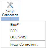
A user can also set up a provider connection using the Setup Connection button.
Setup Connection Options

Add New Connection - Click this selection to edit the Map Connection. You'll be able to set Map Type (Bing, Esri, Google, OGC/WMS, Amap, Geofences, or Worker Path Relay) and then provide the needed connection information (Connection Name, Security Server key, Service URL, Connection Type, Additional Parameters).
Note: Google map support has migrated to the newer Google maps API, which now requires user credentials. In order to make this work, you need to get an API key (see guide here: https://developers.google.com/maps/documentation/maps-static/usage-and-billing). After that, create a new entry in Workbench->Security->EarthWorX Credentials table, where you enter the API key in the Password column and any unique id in the Key column. In the EarthWorX connection setup, use the unique id as the Security Server Key. It works exactly the same as for setting up Bing connections.
Manage Connections - This opens the Map Provider Connections window, where you can edit an existing connection or add a new connection (similar to above).
Proxy Connection - Select Proxy Connection to open Proxy Server Options.
Proxy Server Settings